Goodbye, NOAA-18, You Will Be Missed

For weather hunters and amateur meteorologists, the American NOAA satellite fleets have been workhorses, providing imaging data to meteorology programs of all types the world over. However, over time, these imaging satellites have grown to become complex beasts, with a wide array of sensors to help provide quality imaging of Earth regularly each day.
As the sensor array has grown, the data requirements change and as such, it’s not uncommon to now see weather satellites operating in the microwave bands. While Automatic Picture Transmission mode has been a mainstay for many years, the recent deactivation of NOAA-18 has highlighted the fact that now they are unsupported and they are on borrowed time. Let’s take a quick look back at the fleet and check out some of the last images from the recently deactivated NOOA-18
The Satellites
It’s fair to say that the space race wasn’t just about getting to the moon; it was also about leveraging new and emerging technologies to achieve and maintain a military and scientific edge. Nowhere was this more prevalent than in the development of satellites.
With the early Landsat program of the 70’s being successful in collecting and distributing orbital data, a weather satellite program was the next natural step. While the program has gone through different iterations over the years, it’s been a mainstay of meteorology for decades, providing much in the way of valuable data.
Also known as POES (Polar Operational Environmental Satellites) the program’s first satellite would be launched in 1978 with TIROS-N, before the launch of NOAA-6 the following year would introduce a more standardised format.
16 of these satellites would be launched over the following decades, and while recently decommissioned, NOAA-15 and NOAA-19 are still downloading usable imagery to this day. Due to its relatively long VHF wavelength and strong 5-watt transmitter, the NOAA satellites have been the first step into space communications for many people.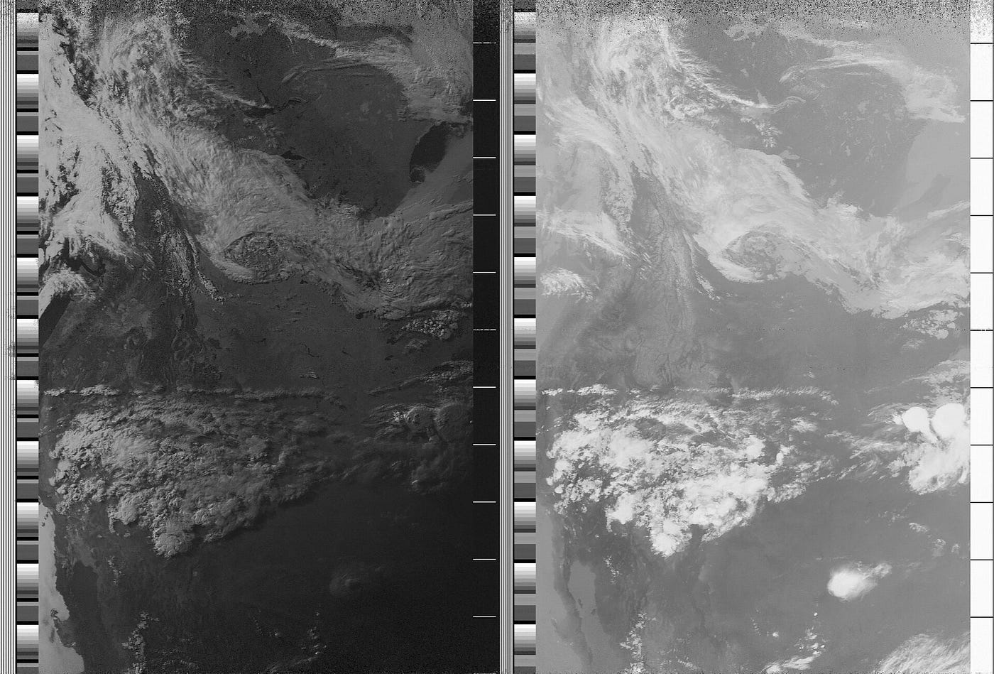 APT has provided images from space for over four decades. Source: Wikipedia
APT Mode
Part of the standardisation process would introduce the Automatic Picture Transmission mode, also known as APT for short. First introduced in the 60s, APT provided effective encoding of data in a mode that was reasonably efficient. With two separate channels providing imagery data and synchronisation information, APT beams only the weather data back, and the sync information allows software to overlay this on maps to achieve usable imagery.
Data is transmitted in horizontal lines, with a complete line being 2080 pixels long at the rate of two lines per second. This allows for a resolution of around 4km per pixel, usable enough for actionable meteorology data.
While it is a reliable mode, due to its analogue nature, APT does not allow for error correction, unlike the later satellites. This means that often, imagery can have noise as the satellite moves through its pass. Due to the usage of a VHF downlink though, those in built-up areas will tend to have much more success in comparison to the later generation, X-band transmitters.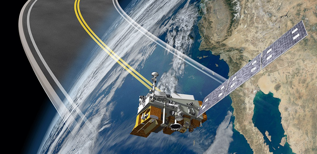 NOAA-20 would be the first of the new-generation fleet. Source: Wikipedia
The Successors
Nowhere does time march on more than in the world of technology and electronics. As such, while the early POES fleet was cutting edge at the time of their launch, they pale in comparison to some of the hardware that's in use in today’s modern systems.
We get a high-speed microwave downlink, built-in error correction to increase signal resistance, and far more information available in terms of channels. The first next-generation satellite, NOAA-20, is a great example of the leap forward that this fleet has given us.
Not only do we get the usual cloud, thermal and radar-based imagery, we now also get Infrared and microwave sounders, a visible infrared radiometer and Cloud and radiant energy emission suite, all beamed back to earth via a high-speed, 7GHz downlink.
With all this considered, it’s easy to see why retiring the aging APT fleet was the sensible choice, but there’s no denying their loss will be profound among the amateur meteorology community.And she’s gone. NOAA-18 passes now result in absolutely nothing. Source: Author
Try It Yourself
With the entire fleet deactivated and rumours of further shutdowns imminent, there’s limited time to use these satellites before they move into the history books.
NOAA-15, for instance, while still active regularly has sensor issues that cause channel loss or incorrect imagery beamed to Earth. When working correctly though, these satellites are still capable of producing stunning imagery on each pass.Imagery from the now-defunct NOAA-18. Picture credit goes to Aang254 on Twitter.
If you’re a fan of the RTL-SDR, you’ll be happy to know that it’s a reasonably easy project to set up using that device, with the stock dipole acting as an acceptable antenna when configured correctly.
In future articles, we’ll be looking at how to intercept some of the more distant geostationary satellites, but for now, the remainder of the POES fleet is the star of the show.
If you’d like to download your own imagery, you can find NOAA-15 on 137.620 MHz (when working correctly), while NOAA-19 downlinks on 137.100 MHz. And, don’t forget to post your results on socials with a tag!
If you found this article insightful, informative, or entertaining, we kindly encourage you to show your support. Clapping for this article not only lets the author know that their work is appreciated but also helps boost its visibility to others who might benefit from it.
🌟 Enjoyed this article? Join the community! 🌟
📢 Join our OSINT Telegram channel for exclusive updates or
📢 Follow our crypto Telegram for the latest giveaways
🐦 Follow us on Twitter and
🟦 We’re now on Bluesky!
🔗 Articles we think you’ll like:
- What The Tech?! Space Shuttles
- Shodan: A Map of the Internet
✉️ Want more content like this? Sign up for email updates