Denizli is a city steeped in history, located in the Aegean Region of Turkey. When we look at its history, it has a rich heritage extending from ancient times to the present day. Denizli, an important settlement especially in ancient times, has hosted many civilizations.
The most important historical heritage of the city is the Ancient City of Hierapolis. This ancient city, which is on the UNESCO World Heritage List, combines with the natural beauties of Pamukkale and offers a magnificent view. Hierapolis was known as an important health center during the Roman Empire. It fascinates its visitors with its ancient theatre, columned streets and ancient thermal pools.
Historical Places:
1- Laodikeia Ancient City: Laodikeia Ancient City was established at a very suitable geographical location and in the south of the Lykos River. The name of the city is mostly mentioned in ancient sources as "Laodicea on the banks of Lykos".
 According to other ancient sources, the city dates back to BC. Between the years 261-263 II. It was founded by Antiochus and the city was named after Antiochus' wife, Laodike. Laodicea is one of the most important and famous cities of Anatolia in the 1st century BC.
 The great works of art in the city belong to this period. The Romans also gave special importance to Laodicea and made it the center of the Kıbyra (Gölhisar-Horzum) Conventus. During the reign of Emperor Caracalla, a series of high-quality coins were minted in Laodicea.
 The fact that one of the most famous churches of Asia Minor is located in this city shows how important Christianity is here. A huge earthquake that occurred in 60 AD destroyed the city.
2- Tripolis Ancient City: Tripolis Ancient City; It was built on a slope on the banks of the Menderes River. It is one of the ancient cities with access to the Aegean Sea through valleys opening to the west and north, and to Central Anatolia and the Mediterranean through the Çürüksu Plain and valleys in the southeast. It is 30 kilometers away from its contemporary Laodikeia, which was founded in the Çürüksu Valley in the south of the city, and 20 kilometers away from Hierapolis. In the sources, there are documents indicating that the first name of Tripolis was Apollonia, later it was called Tripolis in the Late Hellenistic Period and that its first establishment was during the Lydian State.
Although Tripolis is among the Lydian cities, it appears to be one of the important border, trade and agricultural centers providing access to the Phrygian and Carian regions. It is one of the cities that dominates a large part of the Çürüksu Plain, fertilized by the Menderes River and the Çürüksu Stream, and is among the richest cities in the region with its establishment and urbanism approach. Although Tripolis was first founded during the Lydian period, the ruins on the surface show architectural features and building examples from the Roman and Byzantine periods. Tripolis Ancient City BC. II. At the end of the century and in the middle of the 1st century and the 4th century. It was heavily damaged as it was the scene of many earthquakes and wars in the middle of the century. The city experienced its most glorious period during the Roman Era.
3- Çardak Caravanserai: According to the seven-line inscription on the Çardak Caravanserai, it was built by Esededdin Ayaz bin Abdullah el Şahabi, one of his freed slaves and emirs, during the reign of Alaeddin Keykubat. It was completed in Ramadan in 1230 and was built as "Ribat" according to its inscription. Built in the east-west direction, the inn is a simplified version of the sultan inns with its very large square courtyard and a hall consisting of six sections and five aisles. The indoor space has a rectangular plan on the east-west axis. Five naves were formed in four deep rows with five piers in each row. The inn, known as Hanabat when it was a part of Dinar District, was also used as a grain warehouse during the War of Independence.
4- Boğaziçi Town Old Mosque: Boğaziçi Town Old Mosque has a vertical rectangular plan and three naves. It was built in 1181 Hijri. The walls are made of stone down to the foundation level, and the top is made of mud brick. The rectangular planned harim is divided into three aisles with wooden supports. The supports are connected to each other with a Bursa arch. The side walls are supported internally and externally by square wooden poles. The mihrab is in the form of a semicircular niche covered with muqarnas ornament. The wooden pulpit and preaching platform are unadorned. The ceiling and wooden supports have rich hand-carved decorations. The walls of the harim are decorated with murals consisting of floral and geometric decorations and architectural depictions. While the mosque's top was a flat soil roof, its soil was removed and it was covered with a roof sloping in four directions.
5- Temple of Apollo Lairbenos: Located on a small hill called Asartepe, the Temple of Apollo Lairenos was built on a conical-shaped hill overlooking the Menderes Valley. This temple, which at first glance gives the impression of being one of the local cult centers encountered in many regions in Western Anatolia, has attracted the attention of researchers, especially those studying religious history, for a while. Because it is home to one of the types of inscriptions that are of great importance in terms of the history of religions and that are not encountered in any other region of Anatolia, that is, inscriptions called katagraphe, which mean "allocating some people or properties to God". In addition, this modest temple has the distinction of being one of the two regions where inscriptions proving the tradition of confession (Atonement), which was seen only in Western Anatolia and later adopted by Christians, were unearthed.
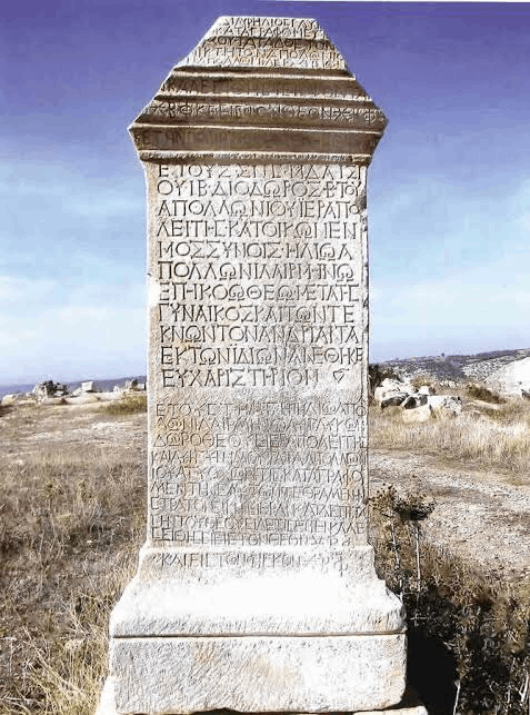 This sacred area, dedicated to Apollo Lairbenos, an Anatolian God, was discovered by researchers WMRamsay, DG Hogarth and HA Brown in May 1887, in the area called Çal Plain today, on the southern bank of the Menderes River, 35 kilometers from Hierapolis. Considering other cult areas in the region, the Sanctuary of Apollo Lairbenos must have been built in the early periods, probably on top of the cult center dedicated to the Goddess Cybele, during the reign of Emperor Hadrian (AD 117-138) and immediately after, in the II century AD. The temple of the god was placed in the far west of the sacred area, at a point overlooking the Menderes Valley. Positioned in the northwest-southeast direction, the temple is on a high podium using the bedrock, has a tetrastyle plan (with four columns on the front) and is in the Corinthian order. The God to whom this Sanctuary is dedicated is usually depicted as a horseman carrying an ear of wheat, an oak branch or a patera (offering bowl) in one hand and a double axe (labrys) in the other hand, and sometimes in the form of a horseman carrying a double ax with a snake wrapped around it on his shoulder. The one who comes out is Apollo Lairbenos.
The name of the god, which appears in 14 different forms in the inscriptions found in the Sanctuary and surrounding villages, appears as "Lairbenos" on Hierapolis coins. Considering the Hierapolis coins, the official form of the god's name "Lairbenos" can perhaps be considered the closest to the original. The fact that the name of God appears in so many different forms in Greek shows that this name is local and that one vowel in it is not fully covered in the Greek alphabet. When we look at the religious atmosphere of Anatolia, especially the Phrygia Region, during the Roman Imperial Period, we see that respect for the Greek gods and the official religions of Rome continued, but at the same time, many local gods and goddesses emerged, often of Greek origin. We see that gods and goddesses are described with local adjectives or worshiped by being mentioned with a place name, thus these religions are Anatolianized. Especially AD II. and III. It is noteworthy that the religious people living in the rural areas of Anatolia and speaking Greek in the 11th century BC moved away from traditional Greek beliefs. Apollo is revered in the sanctuary of Lairbenos, together with his mother Leto and his twin sister Artemis, whom we have seen in every period and every region, and whose relationship is extremely natural. In particular, the belief and devotion to Leto is evidenced by the fact that in a votive inscription found around the temple, Leto is described as "the goddess who makes the impossible possible", independently of Lairbenos.
6-St. Philippe Martyrion Church: Located on a hill in the north of the Hierapolis Ancient City. Philippe Martyrion Church is one of the oldest and most important ruins of the region. St. Philippe is a name among the 12 apostles of Jesus. St. came to the region in 80 AD to spread Christianity. Philippe was killed before he could achieve his goal. It is estimated that Martyrion was built in the memory of St. Philippe at the end of the 4th century AD and the beginning of the 5th century. St. It is thought that Philippe's grave is also here. St. Philippe Martyrion Church is located in the north of the ancient settlement area and is among the most visible historical ruins of Hierapolis...
7- Hierapolis Ancient City: Pamukkale, which is included in almost all lists of places to see before you die and is visited by around 2 million tourists every year, reflects the role of nature as an artist. from the places he assumed. The discovery of the attractiveness of Pamukkale dates back to the Roman Period, where the white travertines formed as a result of the contact of thermal waters with the air formed gradual shapes resembling a frozen waterfall and occasionally formed terrace-shaped pools.
Most of the ruins of the Pamukkale Hierapolis Ancient City, standing in all its glory right next to the Pamukkale Travertines, are also from this period. These ruins, together with the uniquely beautiful travertines, are on the UNESCO World Cultural and Natural Heritage List.
Touristic Places:
1- Pamukkale Travertines: Pamukkale Travertines consist of spring waters and hills with travertine terraces. Located at the foot of Çökelez Mountain and extending 100-150 meters above the plain, this terrace contains thermal springs that create Pamukkale and enable the formation of travertines, approximately 6 km away.
Thermal water coming from the spring in Pamukkale travels a distance of around 320 meters, reaches the travertine head, and from there it pours into the snow-white travertine layers and travels 240-300 meters.
 When water saturated with calcium carbonate evaporates under the sun, the cottony appearance of white travertines in gel form first appears and then solidifies and turns into rocks with crystallized surfaces. In addition to calcium carbonate, it contains sulfate, sodium, iron, potassium, magnesium and free carbon dioxide.
The region, named Pamukkale due to its sedimentary rock travertine terrace, white as cotton and softness in its original form, has 17 hot water areas with temperature ranges of 33-35 °C. It has been known for its healing waters since ancient times and welcomes visitors who want to find healing then as it does today.
2- Cleopatra Pool: The star of Pamukkale, the Ancient Cleopatra Pool, has a deep-rooted history of 2,500 years.
An earthquake in the 7th century AD created a large hole in the middle of the ancient city, and the waters of the thermal baths with healing waters in the region began to collect in the hole that formed over time. Thus, the ancient columns and architectural structures that once formed the magnificent structure of the period turn into a natural pool that forms the basis of this pool. The moment you enter the pool, you feel like you have gone back 2800 years through a mystical underwater door.
There were many baths in the region, which was famous as a healing center before the earthquake. It is known that even at that time, these baths were visited for cleansing and healing. So much so that, during the years when Cleopatra, the Queen of Egypt, was exiled due to the problems she had with her brother, during her travels to reach the lands of the Roman Empire, she heard the praises of the pool and visited this place, and thus the pool was named Cleopatra's Pool.
3- Bağbaşı Plateau: Denizli Bağbaşı Plateau attracts great attention in all 4 seasons of the year. Visitors enjoy cooling off at an altitude of 1400 meters. Citizens who go to Bağbaşı Plateau not only spend time as much as they want, but also find accommodation in bungalows and tents and enjoy local tastes with their loved ones. The region, which is one of the centers of plateau tourism, attracts attention as it is especially preferred by guests coming from outside the city. The region has served millions of visitors to date with facilities such as bungalow houses, nomad tents, restaurants and picnic areas.
4- Yeşildere Waterfall (Crying Rock Waterfall): Yeşildere waterfall, also known as the crying rock waterfall, is located in the Sakızcılar neighborhood of Çal district of Denizli province. It is 40 km and 50 minutes away from the center. The height of the waterfall is approximately 55 meters. There are plane trees in Yeşildere Waterfall that have lived for hundreds of years. Yeşildere Waterfall is a place worth seeing due to its natural beauty. The reason why it is called the weeping rock is that the green stream waterfall in the region resembles a weeping rock.
5- Kaklık Cave: Kaklık Cave is located in Kaklık District of Honaz district, 30 kilometers from Denizli city center on the Denizli-Ankara highway. There is plenty of thermal water in the cave. This clear, colorless and sulfur-scented water is known to be good for some skin diseases. In addition, the swimming pool, small amphitheater, observation areas, cafeteria and pergolas built for the use of visitors near the cave have been put into service for tourism since May 2002. The surroundings of Kaklık Cave, which is an active cave located as a sinkhole-source or sinkhole; It consists of Mesozoic limestones, Eeocene marls, clays, sandstones and conglomerates, Miocene-Pliocene aged clays, sands, marls and limestones, and Quaternary travertines and alluviums.
6- Denizli Rooster: The symbol of Denizli, the "Denizli Rooster", is a local breed that has made a name for itself even to the farthest regions of our city, with its long and beautiful crowings that are harmonious in terms of color and body structure. According to some, it is said that it was produced by the long-crowing Berat roosters brought to Istanbul from Albania during the Ottoman Empire, brought to Denizli and hybridized with local chickens in Denizli, but this is not true. Because there is no similarity between them in terms of color and body structure. Denizli Rooster is a breed that was formed spontaneously as a result of the care that people in this region have given to long-crowing roosters for a long time.