The Oldest Maps in the World: Navigating Ancient Terrain with Ancient Tools

Throughout history, maps have served as vital tools for human exploration and navigation. They not only provide geographical information but also offer a glimpse into the minds of the people and cultures that created them. When it comes to the oldest maps in the world, we are transported back in time, stepping into the shoes of our ancestors who diligently charted the uncharted.
The earliest known maps were created by ancient civilizations that inhabited the fertile lands of the Near East. Mesopotamia, a region located roughly where modern-day Iraq is, holds the honor of producing the oldest known maps. These ancient relics date back to around 2300 BCE, painted on clay tablets using cuneiform script. Primarily used for administrative purposes, these early maps depicted surrounding areas, including rivers, cities, and agricultural plots. Scholars believe that these maps were drawn from an elevated perspective, showcasing the most significant features of the landscape.
Moving further east, China boasts its own record holders in the world of ancient cartography. Dating back to the Shang Dynasty, roughly 1200 BCE, these maps were etched on animal bones and turtle shells, known as oracle bones. Despite their small size, these maps offered a detailed representation of the landscape, including mountains, rivers, and settlements. The sophisticated techniques used to carve these maps indicate a deep understanding of celestial bodies and their alignment with earthly features.
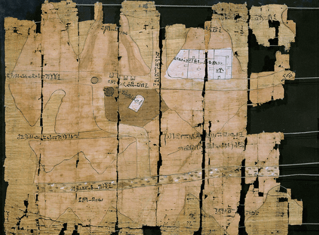
Across the Mediterranean, Egypt's contribution to the world of ancient maps is not to be overlooked. Dating back to the 13th century BCE, an Egyptian map known as the Turin Papyrus stands as one of the oldest surviving examples. Painted on a papyrus scroll, this map depicts a gold mining region in the eastern desert of Egypt. While not as detailed as modern maps, it gives us a valuable glimpse into the world of ancient mining operations and their geographical context.
As we delve even deeper into antiquity, the origins of mapping can be traced back to the Sumerians, a civilization that thrived in Mesopotamia. Cuneiform tablets dating back to the 3rd millennium BCE reveal intricate plans of cities, complete with labeled streets and specific buildings. These ancient urban maps were not only a testament to the Sumerians' advanced architectural and city planning skills but also a visual manifestation of their societal organization.
So, how were these ancient maps drawn? Before the advent of satellite imagery or GPS, our ancestors relied on a combination of observational skills, celestial bodies, and basic surveying techniques. Many of these maps were likely created for administrative and navigational purposes, allowing rulers and travelers to navigate the expansive landscapes they inhabited.
Surveying tools, such as ropes, measuring sticks, and sighting rods, were used to measure distances and create accurate representations. Astronomical observations played a significant role as well, enabling early cartographers to align their maps with celestial bodies or cardinal directions. These ancient mapmakers utilized their knowledge of the stars, sun, and moon to create maps that aligned with the natural world around them.
Today, with the help of technology, we can instantly access highly accurate and detailed maps of any location on Earth. But as we marvel at the convenience and precision of modern maps, let us not forget the pioneering efforts of our ancestors. These ancient maps, created with crude tools and a deep connection to the environment, provide us with a glimpse into the minds of those who came before us, reminding us of our shared human heritage and the innate curiosity that has propelled us forward through time.