Berlin
Berlin
This article is about the capital city of Germany. For other uses, see Berlin (disambiguation).
Berlin
Capital city, state and municipality
Spree river, Museum Island and Berlin TV Tower in Mitte
Nicknames: Grey City[1]
"Spreeathen", or Athens on the Spree River[2]
Show Berlin
Show Europe
Show all
Coordinates:  52°31′12″N 13°24′18″ECountryGermanyStateBerlinGovernment • BodyAbgeordnetenhaus of Berlin • Governing MayorKai Wegner (CDU) • Bundesrat votes4 (of 69) • Bundestag seats29 (of 736)Area[3] • City/State891.3 km2 (344.1 sq mi) • Urban3,743 km2 (1,445 sq mi) • Metro30,546 km2 (11,794 sq mi)Elevation34 m (112 ft)Population (2022)[4] • City/State3,755,251 • Rank5th in Europe
1st in Germany • Density4,213/km2 (10,910/sq mi) • Urban[5]4,768,142 • Urban density1,274/km2 (3,300/sq mi) • Metro[6]6,144,600 • Metro density201/km2 (520/sq mi)DemonymsBerliner(s) (English)
Berliner (m), Berlinerin (f) (German)GDP[7][8] • City/State€179.379 billion (2022) • Metro€268.179 billion (2022)Time zoneUTC+01:00 (CET) • Summer (DST)UTC+02:00 (CEST)Area codes030GeocodeNUTS Region: DE3ISO 3166 codeDE-BEVehicle registrationBGeoTLD.berlinHDI (2019)0.964[9]
very high · 2nd of 16Websiteberlin.de
Berlin (/bɜːrˈlɪn/, bur-LIN; German: [bɛʁˈliːn] ⓘ)[10] is the capital and largest city of Germany, both by area and by population.[11] Its more than 3.85 million inhabitants[12] make it the European Union's most populous city, as measured by population within city limits.[4] Simultaneously, the city is one of the States of Germany and is the third smallest state in the country in terms of area. Berlin is surrounded by the state of Brandenburg, and Brandenburg's capital Potsdam is nearby. The urban area of Berlin has a population of 4.5 million and is therefore the most populous urban area in Germany.[5][13] The Berlin-Brandenburg capital region has around 6.2 million inhabitants and is Germany's second-largest metropolitan region after the Rhine-Ruhr region, and the sixth-biggest metropolitan region by GDP in the European Union.[14]
Berlin was built along the banks of the Spree river, which flows into the Havel in the western borough of Spandau. The city incorporates lakes in the western and southeastern boroughs, the largest of which is Müggelsee. About one-third of the city's area is composed of forests, parks and gardens, rivers, canals, and lakes.[15]
First documented in the 13th century[10] and at the crossing of two important historic trade routes,[16] Berlin was designated the capital of the Margraviate of Brandenburg (1417–1701), Kingdom of Prussia (1701–1918), German Empire (1871–1918), Weimar Republic (1919–1933), and Nazi Germany (1933–1945). Berlin has served as a scientific, artistic, and philosophical hub during the Age of Enlightenment, Neoclassicism, and the German revolutions of 1848–1849. During the Gründerzeit, an industrialization-induced economic boom triggered a rapid population increase in Berlin. 1920s Berlin was the third-largest city in the world by population.[17]
After World War II and following Berlin's occupation, the city was split into West Berlin and East Berlin, divided by the Berlin Wall.[18] East Berlin was declared the capital of East Germany, while Bonn became the West German capital. Following German reunification in 1990, Berlin once again became the capital of all of Germany.
The economy of Berlin is based on high tech and the service sector, encompassing a diverse range of creative industries, startup companies, research facilities, and media corporations.[19][20] Berlin serves as a continental hub for air and rail traffic and has a complex public transportation network. Tourism in Berlin make the city a popular global destination.[21] Significant industries include information technology, the healthcare industry, biomedical engineering, biotechnology, the automotive industry, and electronics.
Berlin is home to several universities such as the Humboldt University of Berlin, the Technical University of Berlin, the Berlin University of the Arts and the Free University of Berlin. The Berlin Zoological Garden is the most visited zoo in Europe. Babelsberg Studio is the world's first large-scale movie studio complex and the list of films set in Berlin is long.[22]
Berlin is also home to three World Heritage Sites. Museum Island, the Palaces and Parks of Potsdam and Berlin, and the Berlin Modernism Housing Estates.[23] Other landmarks include the Brandenburg Gate, the Reichstag building, Potsdamer Platz, the Memorial to the Murdered Jews of Europe, and the Berlin Wall Memorial. Berlin has numerous museums, galleries, and libraries.
History[edit]
Main article: History of Berlin
For a chronological guide, see Timeline of Berlin.
Historical affiliations
Margraviate of Brandenburg 1237–1618
Brandenburg-Prussia 1618–1701
Kingdom of Prussia 1701–1867
North German Confederation 1867–1871
German Empire 1871–1918
Weimar Republic 1918–1933
Nazi Germany 1933–1945
Allied-occupied Germany 1945–1949
West Germany 1949–1990
East Germany 1949–1990
Germany 1990–present
Etymology[edit]
Berlin lies in northeastern Germany. Most of the cities and villages in northeastern Germany bear Slavic languages-derived names. Typical Germanization for place name suffixes of Slavic origin are -ow, -itz, -vitz, -witz, -itzsch and -in, prefixes are Windisch and Wendisch. The name Berlin has its roots in the language of the West Slavs, and may be related to the Old Polabian stem berl-/birl- ("swamp").[24]
Of Berlin's twelve boroughs, five bear a Slavic-derived name: Pankow, Steglitz-Zehlendorf, Marzahn-Hellersdorf, Treptow-Köpenick, and Spandau. Of Berlin's ninety-six neighborhoods, twenty-two bear a Slavic-derived name: Altglienicke, Alt-Treptow, Britz, Buch, Buckow, Gatow, Karow, Kladow, Köpenick, Lankwitz, Lübars, Malchow, Marzahn, Pankow, Prenzlauer Berg, Rudow, Schmöckwitz, Spandau, Stadtrandsiedlung Malchow, Steglitz, Tegel and Zehlendorf.
Prehistory of Berlin[edit]
The earliest human settlements in the area of modern Berlin are dated around 60,000 BC. A deer mask, dated to 9,000 BC, is attributed to the Maglemosian culture. In 2,000 BC dense human settlements along the Spree and Havel rivers gave rise to the Lusatian culture.[25] Starting around 500 BC Germanic tribes settled in a number of villages in the higher situated areas of today's Berlin. After the Semnones left around 200 AD, the Burgundians followed. In the 7th century Slavic tribes, the later known Hevelli and Sprevane, reached the region.
12th century to 16th century[edit]
 Map of Berlin in 1688
 Berlin Cathedral (left) and Berlin Palace (right), 1900
In the 12th century the region came under German rule as part of the Margraviate of Brandenburg, founded by Albert the Bear in 1157. Early evidence of middle age settlements in the area of today's Berlin are remnants of a house foundation dated 1270 to 1290, found in excavations in Berlin Mitte.[26] The first written records of towns in the area of present-day Berlin date from the late 12th century. Spandau is first mentioned in 1197 and Köpenick in 1209.[27] 1237 is considered the founding date of the city.[28] The two towns over time formed close economic and social ties, and profited from the staple right on the two important trade routes, one was known as Via Imperii, and the other trade route reached from Bruges to Novgorod.[16] In 1307 the two towns formed an alliance with a common external policy, their internal administrations still being separated.[29]
Members of the Hohenzollern family ruled in Berlin until 1918, first as electors of Brandenburg, then as kings of Prussia, and eventually as German emperors. In 1443, Frederick II Irontooth started the construction of a new royal palace in the twin city Berlin-Cölln. The protests of the town citizens against the building culminated in 1448, in the "Berlin Indignation" ("Berliner Unwille").[30] Officially, the Berlin-Cölln palace became permanent residence of the Brandenburg electors of the Hohenzollerns from 1486, when John Cicero came to power.[31] Berlin-Cölln, however, had to give up its status as a free Hanseatic League city. In 1539, the electors and the city officially became Lutheran.[32]
17th to 19th centuries[edit]
The Thirty Years' War between 1618 and 1648 devastated Berlin. One third of its houses were damaged or destroyed, and the city lost half of its population.[33] Frederick William, known as the "Great Elector", who had succeeded his father George William as ruler in 1640, initiated a policy of promoting immigration and religious tolerance.[34] With the Edict of Potsdam in 1685, Frederick William offered asylum to the French Huguenots.[35]
By 1700, approximately 30 percent of Berlin's residents were French, because of the Huguenot immigration.[36] Many other immigrants came from Bohemia, Poland, and Salzburg.[37] Berlin became the capital of the German Empire in 1871 and expanded rapidly in the following years.
Since 1618, the Margraviate of Brandenburg had been in personal union with the Duchy of Prussia. In 1701, the dual state formed the Kingdom of Prussia, as Frederick III, Elector of Brandenburg, crowned himself as king Frederick I in Prussia. Berlin became the capital of the new Kingdom,[38] replacing Königsberg. This was a successful attempt to centralise the capital in the very far-flung state, and it was the first time the city began to grow. In 1709, Berlin merged with the four cities of Cölln, Friedrichswerder, Friedrichstadt and Dorotheenstadt under the name Berlin, "Haupt- und Residenzstadt Berlin".[29]
In 1740, Frederick II, known as Frederick the Great (1740–1786), came to power.[39] Under the rule of Frederick II, Berlin became a center of the Enlightenment, but also, was briefly occupied during the Seven Years' War by the Russian army.[40] Following France's victory in the War of the Fourth Coalition, Napoleon Bonaparte marched into Berlin in 1806, but granted self-government to the city.[41] In 1815, the city became part of the new Province of Brandenburg.[42]
The Industrial Revolution transformed Berlin during the 19th century; the city's economy and population expanded dramatically, and it became the main railway hub and economic center of Germany. Additional suburbs soon developed and increased the area and population of Berlin. In 1861, neighboring suburbs including Wedding, Moabit and several others were incorporated into Berlin.[43] In 1871, Berlin became capital of the newly founded German Empire.[44] In 1881, it became a city district separate from Brandenburg.[45]
20th to 21st centuries[edit]
Further information: 1920s Berlin, West Berlin, and East Berlin
In the early 20th century, Berlin had become a fertile ground for the German Expressionist movement.[46] In fields such as architecture, painting and cinema new forms of artistic styles were invented. At the end of the First World War in 1918, a republic was proclaimed by Philipp Scheidemann at the Reichstag building. In 1920, the Greater Berlin Act incorporated dozens of suburban cities, villages, and estates around Berlin into an expanded city. The act increased the area of Berlin from 66 to 883 km2 (25 to 341 sq mi). The population almost doubled, and Berlin had a population of around four million. During the Weimar era, Berlin underwent political unrest due to economic uncertainties but also became a renowned center of the Roaring Twenties. The metropolis experienced its heyday as a major world capital and was known for its leadership roles in science, technology, arts, the humanities, city planning, film, higher education, government, and industries. Albert Einstein rose to public prominence during his years in Berlin,[47] being awarded the Nobel Prize for Physics in 1921.[48]
In 1933, Adolf Hitler and the Nazi Party came to power. Hitler was inspired by the architecture he had experienced in Vienna, and he wished for a German Empire with a capital city that had a monumental ensemble. The National Socialist regime embarked on monumental construction projects in Berlin as a way to express their power and authority through architecture. Adolf Hitler and Albert Speer developed architectural concepts for the conversion of the city into World Capital Germania; these were never implemented.[49]
NSDAP rule diminished Berlin's Jewish community from 160,000 (one-third of all Jews in the country) to about 80,000 due to emigration between 1933 and 1939. After Kristallnacht in 1938, thousands of the city's Jews were imprisoned in the nearby Sachsenhausen concentration camp. Starting in early 1943, many were deported to ghettos like Łódź, and to concentration and extermination camps such as Auschwitz.[50]
Berlin hosted the 1936 Summer Olympics for which the Olympic stadium was built.[51] Berlin in ruins after World War II (Potsdamer Platz, 1945)
During World War II, large parts of Berlin were destroyed during 1943–45 Allied air raids and the 1945 Battle of Berlin. The Allies dropped 67,607 tons of bombs on the city, destroying 6,427 acres of the built-up area. Around 125,000 civilians were killed.[52] After the end of World War II in Europe in May 1945, Berlin received large numbers of refugees from the Eastern provinces. The victorious powers divided the city into four sectors, analogous to Allied-occupied Germany the sectors of the Allies of World War II (the United States, the United Kingdom, and France) formed West Berlin, while the Soviet Union formed East Berlin.[53]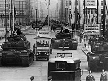 US and Soviet tanks face each other. Taken in 1961 at Checkpoint Charlie.
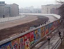 The Berlin Wall (painted on the western side) was a barrier that divided the city from 1961 to 1989.
All four Allies of World War II shared administrative responsibilities for Berlin. However, in 1948, when the Western Allies extended the currency reform in the Western zones of Germany to the three western sectors of Berlin, the Soviet Union imposed the Berlin Blockade on the access routes to and from West Berlin, which lay entirely inside Soviet-controlled territory. The Berlin airlift, conducted by the three western Allies, overcame this blockade by supplying food and other supplies to the city from June 1948 to May 1949.[54] In 1949, the Federal Republic of Germany was founded in West Germany and eventually included all of the American, British and French zones, excluding those three countries' zones in Berlin, while the Marxist–Leninist German Democratic Republic was proclaimed in East Germany. West Berlin officially remained an occupied city, but it politically was aligned with the Federal Republic of Germany despite West Berlin's geographic isolation. Airline service to West Berlin was granted only to American, British and French airlines. The fall of the Berlin Wall on 9 November 1989. On 3 October 1990, the German reunification process was formally finished.
The founding of the two German states increased Cold War tensions. West Berlin was surrounded by East German territory, and East Germany proclaimed the Eastern part as its capital, a move the western powers did not recognize. East Berlin included most of the city's historic center. The West German government established itself in Bonn.[55] In 1961, East Germany began to build the Berlin Wall around West Berlin, and events escalated to a tank standoff at Checkpoint Charlie. West Berlin was now de facto a part of West Germany with a unique legal status, while East Berlin was de facto a part of East Germany. John F. Kennedy gave his "Ich bin ein Berliner" speech on 26 June 1963, in front of the Schöneberg city hall, located in the city's western part, underlining the US support for West Berlin.[56] Berlin was completely divided. Although it was possible for Westerners to pass to the other side through strictly controlled checkpoints, for most Easterners, travel to West Berlin or West Germany was prohibited by the government of East Germany. In 1971, a Four-Power agreement guaranteed access to and from West Berlin by car or train through East Germany.[57]
In 1989, with the end of the Cold War and pressure from the East German population, the Berlin Wall fell on 9 November and was subsequently mostly demolished. Today, the East Side Gallery preserves a large portion of the wall. On 3 October 1990, the two parts of Germany were reunified as the Federal Republic of Germany, and Berlin again became a reunified city. After the fall of the Berlin Wall, the city experienced significant urban development and still impacts urban planning decisions.
[58] Walter Momper, the mayor of West Berlin, became the first mayor of the reunified city in the interim.[59] City-wide elections in December 1990 resulted in the first "all Berlin" mayor being elected to take office in January 1991, with the separate offices of mayors in East and West Berlin expiring by that time, and Eberhard Diepgen (a former mayor of West Berlin) became the first elected mayor of a reunited Berlin.[60] On 18 June 1994, soldiers from the United States, France and Britain marched in a parade which was part of the ceremonies to mark the withdrawal of allied occupation troops allowing a reunified Berlin[61] (the last Russian troops departed on 31 August, while the final departure of Western Allies forces was on 8 September 1994). On 20 June 1991, the Bundestag (German Parliament) voted to move the seat of the German capital from Bonn to Berlin, which was completed in 1999, during the chancellorship of Gerhard Schröder.[62]
The rebuilt Berlin Palace in 2022
Berlin's 2001 administrative reform merged several boroughs, reducing their number from 23 to 12.[63]
In 2006, the FIFA World Cup Final was held in Berlin.[64]
Construction of the "Berlin Wall Trail" (Berliner Mauerweg) began in 2002 and was completed in 2006.
In a 2016 terrorist attack linked to ISIL, a truck was deliberately driven into a Christmas market next to the Kaiser Wilhelm Memorial Church, leaving 13 people dead and 55 others injured.[65][66]
In 2018, more than 200,000 protestors took to the streets in Berlin with demonstrations of solidarity against racism, in response to the emergence of far-right politics in Germany.[67]
Berlin Brandenburg Airport (BER) opened in 2020, nine years later than planned, with Terminal 1 coming into service at the end of October, and flights to and from Tegel Airport ending in November.[68] Due to the fall in passenger numbers resulting from the COVID-19 pandemic, plans were announced to temporarily close BER's Terminal 5, the former Schönefeld Airport, beginning in March 2021 for up to one year.[69] The connecting link of U-Bahn line U5 from Alexanderplatz to Hauptbahnhof, along with the new stations Rotes Rathaus and Unter den Linden, opened on 4 December 2020, with the Museumsinsel U-Bahn station expected to open around March 2021, which would complete all new works on the U5.[70]
A partial opening by the end of 2020 of the Humboldt Forum museum, housed in the reconstructed Berlin Palace, which had been announced in June, was postponed until March 2021.[71] On 16 September 2022, the opening of the eastern wing, the last section of the Humboldt Forum museum, meant the Humboldt Forum museum was finally completed. It became Germany's currently most expensive cultural project.[72]
Berlin-Brandenburg fusion attempt[edit]
Main article: Fusion of Berlin and Brandenburg The coat of arms proposed in the state contract
The legal basis for a combined state of Berlin and Brandenburg is different from other state fusion proposals. Normally, Article 29 of the Basic Law stipulates that a state fusion requires a federal law.[73] However, a clause added to the Basic Law in 1994, Article 118a, allows Berlin and Brandenburg to unify without federal approval, requiring a referendum and a ratification by both state parliaments.[74]
In 1996, there was an unsuccessful attempt of unifying the states of Berlin and Brandenburg.[75] Both share a common history, dialect and culture and in 2020, there are over 225.000 residents of Brandenburg that commute to Berlin. The fusion had the near-unanimous support by a broad coalition of both state governments, political parties, media, business associations, trade unions and churches.[76] Though Berlin voted in favor by a small margin, largely based on support in former West Berlin, Brandenburg voters disapproved of the fusion by a large margin. It failed largely due to Brandenburg voters not wanting to take on Berlin's large and growing public debt and fearing losing identity and influence to the capital.[75]
Geography[edit]
Main article: Geography of Berlin
Topography[edit]
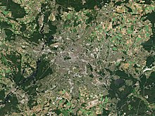 Satellite image of Berlin
 The outskirts of Berlin are covered with woodlands and numerous lakes.
Berlin is in northeastern Germany, in an area of low-lying marshy woodlands with a mainly flat topography, part of the vast Northern European Plain which stretches all the way from northern France to western Russia. The Berliner Urstromtal (an ice age glacial valley), between the low Barnim Plateau to the north and the Teltow plateau to the south, was formed by meltwater flowing from ice sheets at the end of the last Weichselian glaciation. The Spree follows this valley now. In Spandau, a borough in the west of Berlin, the Spree empties into the river Havel, which flows from north to south through western Berlin. The course of the Havel is more like a chain of lakes, the largest being the Tegeler See and the Großer Wannsee. A series of lakes also feeds into the upper Spree, which flows through the Großer Müggelsee in eastern Berlin.[77]
Substantial parts of present-day Berlin extend onto the low plateaus on both sides of the Spree Valley. Large parts of the boroughs Reinickendorf and Pankow lie on the Barnim Plateau, while most of the boroughs of Charlottenburg-Wilmersdorf, Steglitz-Zehlendorf, Tempelhof-Schöneberg, and Neukölln lie on the Teltow Plateau.
The borough of Spandau lies partly within the Berlin Glacial Valley and partly on the Nauen Plain, which stretches to the west of Berlin. Since 2015, the Arkenberge hills in Pankow at 122 meters (400 ft) elevation, have been the highest point in Berlin. Through the disposal of construction debris they surpassed Teufelsberg (120.1 m or 394 ft), which itself was made up of rubble from the ruins of the Second World War.[78] The Müggelberge at 114.7 meters (376 ft) elevation is the highest natural point and the lowest is the Spektesee in Spandau, at 28.1 meters (92 ft) elevation.[79]
Climate[edit]
Berlin has an oceanic climate (Köppen: Cfb)[80] bordering on a humid continental climate (Dfb). This type of climate features mild to very warm summer temperatures and cold, though not very severe, winters. Annual precipitation is modest.[81][82]
Frosts are common in winter, and there are larger temperature differences between seasons than typical for many oceanic climates. Summers are warm and sometimes humid with average high temperatures of 22–25 °C (72–77 °F) and lows of 12–14 °C (54–57 °F). Winters are cold with average high temperatures of 3 °C (37 °F) and lows of −2 to 0 °C (28 to 32 °F). Spring and autumn are generally chilly to mild. Berlin's built-up area creates a microclimate, with heat stored by the city's buildings and pavement. Temperatures can be 4 °C (7 °F) higher in the city than in the surrounding areas.[83] Annual precipitation is 570 millimeters (22 in) with moderate rainfall throughout the year. Snowfall mainly occurs from December through March.[84] The hottest month in Berlin was July 1834, with a mean temperature of 23.0 °C (73.4 °F) and the coldest was January 1709, with a mean temperature of −13.2 °C (8.2 °F).[85] The wettest month on record was July 1907, with 230 millimeters (9.1 in) of rainfall, whereas the driest were October 1866, November 1902, October 1908 and September 1928, all with 1 millimeter (0.039 in) of rainfall.[86]
hide
Climate data for Berlin Brandenburg 1991–2020, extremes 1957–2021MonthJanFebMarAprMayJunJulAugSepOctNovDecYearRecord high °C (°F)15.1
(59.2)19.2
(66.6)25.8
(78.4)30.8
(87.4)32.7
(90.9)38.4
(101.1)38.3
(100.9)38.0
(100.4)32.3
(90.1)27.7
(81.9)20.9
(69.6)15.6
(60.1)38.4
(101.1)Mean maximum °C (°F)10.6
(51.1)12.4
(54.3)17.9
(64.2)24.0
(75.2)28.4
(83.1)31.5
(88.7)32.7
(90.9)32.7
(90.9)26.9
(80.4)21.5
(70.7)14.8
(58.6)11.2
(52.2)34.8
(94.6)Mean daily maximum °C (°F)3.2
(37.8)4.9
(40.8)9.0
(48.2)15.1
(59.2)19.6
(67.3)22.9
(73.2)25.0
(77.0)24.8
(76.6)19.8
(67.6)13.9
(57.0)7.7
(45.9)4.1
(39.4)14.2
(57.5)Daily mean °C (°F)0.7
(33.3)1.6
(34.9)4.6
(40.3)9.7
(49.5)14.2
(57.6)17.6
(63.7)19.6
(67.3)19.2
(66.6)14.7
(58.5)9.6
(49.3)4.9
(40.8)1.8
(35.2)9.9
(49.8)Mean daily minimum °C (°F)−2.2
(28.0)−1.8
(28.8)0.4
(32.7)4.0
(39.2)8.2
(46.8)11.7
(53.1)14.0
(57.2)13.5
(56.3)9.8
(49.6)5.6
(42.1)1.9
(35.4)−0.9
(30.4)5.3
(41.6)Mean minimum °C (°F)−12.0
(10.4)−9.5
(14.9)−5.8
(21.6)−2.6
(27.3)1.7
(35.1)6.3
(43.3)8.9
(48.0)8.1
(46.6)3.9
(39.0)−1.3
(29.7)−5.0
(23.0)−8.9
(16.0)−14.2
(6.4)Record low °C (°F)−25.3
(−13.5)−22.0
(−7.6)−19.1
(−2.4)−7.4
(18.7)−2.8
(27.0)1.3
(34.3)4.9
(40.8)4.6
(40.3)−0.9
(30.4)−7.7
(18.1)−17.8
(0.0)−24.0
(−11.2)−25.3
(−13.5)Average precipitation mm (inches)41.5
(1.63)30.0
(1.18)35.9
(1.41)27.7
(1.09)52.8
(2.08)60.2
(2.37)70.0
(2.76)52.4
(2.06)43.6
(1.72)40.3
(1.59)38.8
(1.53)39.1
(1.54)532.3
(20.96)Mean monthly sunshine hours52.677.9126.7196.4231.1232.9233.7222.2168.9113.857.445.01,758.6Source: Data derived from Deutscher Wetterdienst[87]
show
Climate data for Berlin (Schönefeld), 1981–2010 normals, extremes 1957–present
show
Climate data for Berlin (Tempelhof), elevation: 48 m or 157 ft, 1971–2000 normals, extremes 1878–present
show
Climate data for Berlin (Dahlem), 58 m or 190 ft, 1961–1990 normals, extremes 1908–present
Cityscape[edit]
 Aerial photo over central Berlin showing City West, Potsdamer Platz, and Alexanderplatz
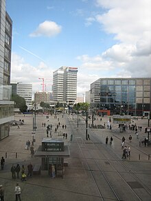 Alexanderplatz panorama
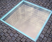 A memorial to the Nazi book burning by Micha Ullman set into the Bebelplatz
Berlin's history has left the city with a polycentric metropolitan area and an eclectic mix of architecture. The city's appearance today has been predominantly shaped by German history during the 20th century.
Devastated by the bombing of Berlin in World War II many of the buildings that had survived in both East and West were demolished during the postwar period. After the reunification, many important heritage structures have been reconstructed, including the Forum Fridericianum along with, the Berlin State Opera, Charlottenburg Palace, Gendarmenmarkt, Alte Kommandantur, as well as the City Palace.
The list of tallest buildings in Berlin spreads across the urban area, they can be found for example at Potsdamer Platz, the City West, and Alexanderplatz.
Over one-third of the city area consists of green space, woodlands, and water.[15] Berlin's second-largest and most popular park, the Großer Tiergarten, is located right in the center of the city.
Architecture[edit]
Main article: Architecture of Berlin
Further information: List of sights in Berlin and List of tallest buildings in Berlin Panorama of the Gendarmenmarkt, showing the Konzerthaus Berlin, flanked by the German Church (left) and French Church (right)
 The Berlin Cathedral at Museum Island
 The TV Tower (Berliner Fernsehturm)
The Fernsehturm (TV tower) at Alexanderplatz in Mitte is among the tallest structures in the European Union at 368 m (1,207 ft). Built in 1969, it is visible throughout most of the central districts of Berlin. Berlin TV tower Dec 2023
The city can be viewed from its 204-meter-high (669 ft) observation floor. Starting here, the Karl-Marx-Allee heads east, an avenue lined by monumental residential buildings, designed in the Socialist Classicism style. Adjacent to this area is the Rotes Rathaus (City Hall), with its distinctive red-brick architecture. In front of it is the Neptunbrunnen, a fountain featuring a mythological group of Tritons, personifications of the four main Prussian rivers, and Neptune on top of it.
The Brandenburg Gate is an iconic landmark of Berlin and Germany; it stands as a symbol of eventful European history and of unity and peace. The Reichstag building is the traditional seat of the German Parliament. It was remodeled by British architect Norman Foster in the 1990s and features a glass dome over the session area, which allows free public access to the parliamentary proceedings and magnificent views of the city.
The East Side Gallery is an open-air exhibition of art painted directly on the last existing portions of the Berlin Wall. It is the largest remaining evidence of the city's historical division.
The Gendarmenmarkt is a neoclassical square in Berlin, the name of which derives from the headquarters of the famous Gens d'armes regiment located here in the 18th century. Two similarly designed cathedrals border it, the Französischer Dom with its observation platform and the Deutscher Dom. The Konzerthaus (Concert Hall), home of the Berlin Symphony Orchestra, stands between the two cathedrals. Charlottenburg Palace
 Hackesche Höfe
The Museum Island in the River Spree houses five museums built from 1830 to 1930 and is a UNESCO World Heritage site. Restoration and construction of a main entrance to all museums, as well as reconstruction of the Stadtschloss continues.[94][95] Also on the island and next to the Lustgarten and palace is Berlin Cathedral, emperor William II's ambitious attempt to create a Protestant counterpart to St. Peter's Basilica in Rome. A large crypt houses the remains of some of the earlier Prussian royal family. St. Hedwig's Cathedral is Berlin's Roman Catholic cathedral.


