Asia

Asia
This article is about the continent. For other uses, see Asia (disambiguation).
- Asia
 Area44,579,000 km2 (17,212,000 sq mi) (1st)[1]Population4,694,576,167 (2021; 1st)[2][3]Population density100/km2 (260/sq mi)GDP (PPP)$72.7 trillion (2022 est; 1st)[4]GDP (nominal)$39 trillion (2022 est; 1st)[5]GDP per capita$8,890 (2022 est; 4th)[6]ReligionsIslam (28.0%)
 - Hinduism (22.8%)
- No religion (13.9%)
- Buddhism (11.1%)
- Chinese folk religion (9.7%)
- Christianity (8.4%)
- Ethnic religions (3.5%)
- New religions (1.3%)
- Other (1.3%)[7]
_without_New_Guinea.svg)
DemonymAsianCountries49 UN members
1 UN observer
5 other statesDependenciesshow
List
Non-UN statesshow
List
- LanguagesList of languagesTime zonesUTC+02:00 to UTC+12:00Internet TLD.asiaLargest citiesList of metropolitan areas
- Lists of cities
UN M49 code142 – Asia001 – World_with_legend.jpg) Map of the most populous part of Asia showing physical, political, and population characteristics, as per 2018
Map of the most populous part of Asia showing physical, political, and population characteristics, as per 2018
Asia (/ˈeɪʒə/ ⓘ AY-zhə, UK also /ˈeɪʃə/ AY-shə) is the largest continent[note 1][10][11] in the world by both land area and population.[11] It covers an area of more than 44 million square kilometers,[note 2] about 30% of Earth's total land area and 8% of Earth's total surface area. The continent, which has long been home to the majority of the human population,[12] was the site of many of the first civilizations. Its 4.7 billion people[13] constitute roughly 60% of the world's population.[14]
Asia shares the landmass of Eurasia with Europe, and of Afro-Eurasia with both Europe and Africa. In general terms, it is bounded on the east by the Pacific Ocean, on the south by the Indian Ocean, and on the north by the Arctic Ocean. The border of Asia with Europe is a historical and cultural construct, as there is no clear physical and geographical separation between them. It is somewhat arbitrary and has moved since its first conception in classical antiquity. The division of Eurasia into two continents reflects East–West cultural, linguistic, and ethnic differences, some of which vary on a spectrum rather than with a sharp dividing line. A commonly accepted division places Asia to the east of the Suez Canal separating it from Africa; and to the east of the Turkish Straits, the Ural Mountains and Ural River, and to the south of the Caucasus Mountains and the Caspian and Black seas, separating it from Europe.[15]
China and India traded places as the largest economies in the world from 1 to 1800 CE. China was a major economic power for much of recorded history, with the highest GDP per capita until 1500,[16][17][18] and for many the legendary wealth and prosperity of the ancient culture of India personified Asia,[19] attracting European commerce, exploration, and colonialism. The Silk Road became the main east–west trading route in the Asian hinterlands while the Straits of Malacca stood as a major sea route. Asia has exhibited economic dynamism as well as robust population growth during the 20th century, but overall population growth has since fallen.[20] Asia was the birthplace of most of the world's mainstream religions including Hinduism, Zoroastrianism, Judaism, Jainism, Buddhism, Confucianism, Taoism, Christianity, Islam, Sikhism, as well as many other religions.
Asia varies greatly across and within its regions with regard to ethnic groups, cultures, environments, economics, historical ties and government systems. It also has a mix of many different climates ranging from the equatorial south via the hot desert in the Middle East, temperate areas in the east and the continental centre to vast subarctic and polar areas in Siberia.
Definition and boundaries
Further information on Asian borders: Geography of Asia § Boundary, Boundaries between the continents, List of transcontinental countries § Asia and Europe, and Copenhagen criteria
Asia–Africa boundary
The boundary between Asia and Africa is the Suez Canal, the Gulf of Suez, the Red Sea, and the Bab-el-Mandeb.[21] This makes Egypt a transcontinental country, with the Sinai peninsula in Asia and the remainder of the country in Africa.
Asia–Europe boundary
 Definitions used for the boundary between Asia and Europe in different periods of history. The commonly accepted modern definition mostly fits with the lines "B" and "F" in this image.
The threefold division of the Old World into Africa, Asia, and Europe has been in use since the 6th century BCE, due to Greek geographers such as Anaximander and Hecataeus.[citation needed] Anaximander placed the boundary between Asia and Europe along the Phasis River (the modern Rioni river) in Georgia of Caucasus (from its mouth by Poti on the Black Sea coast, through the Surami Pass and along the Kura River to the Caspian Sea), a convention still followed by Herodotus in the 5th century BCE.[22] During the Hellenistic period,[23] this convention was revised, and the boundary between Europe and Asia was now considered to be the Tanais (the modern Don River). This is the convention used by Roman era authors such as Posidonius,[24] Strabo[25] and Ptolemy.[26]
The border between Asia and Europe was historically defined by European academics.[27] The Don River became unsatisfactory to northern Europeans when Peter the Great, king of the Tsardom of Russia, defeating rival claims of Sweden and the Ottoman Empire to the eastern lands, and armed resistance by the tribes of Siberia, synthesized a new Russian Empire extending to the Ural Mountains and beyond, founded in 1721.[citation needed]
In Sweden, five years after Peter's death, in 1730 Philip Johan von Strahlenberg published a new atlas proposing the Ural Mountains as the border of Asia. Tatishchev announced that he had proposed the idea to von Strahlenberg. The latter had suggested the Emba River as the lower boundary. Over the next century various proposals were made until the Ural River prevailed in the mid-19th century. The border had been moved perforce from the Black Sea to the Caspian Sea into which the Ural River projects.[28] The border between the Black Sea and the Caspian is usually placed along the crest of the Caucasus Mountains, although it is sometimes placed further north.[27]
Asia–Oceania boundary
The border between Asia and the region of Oceania is usually placed somewhere in the Indonesia Archipelago. The Maluku Islands are often considered to lie on the border of southeast Asia, with Indonesian New Guinea, to the east of the islands, being wholly part of Oceania. The terms Southeast Asia and Oceania, devised in the 19th century, have had several vastly different geographic meanings since their inception. The chief factor in determining which islands of the Indonesian Archipelago are Asian has been the location of the colonial possessions of the various empires there (not all European). Lewis and Wigen assert, "The narrowing of 'Southeast Asia' to its present boundaries was thus a gradual process."[29]
Asia–North America boundary
The Bering Strait and Bering Sea separate the landmasses of Asia and North America, as well as forming the international boundary between Russia and the United States. This national and continental boundary separates the Diomede Islands in the Bering Strait, with Big Diomede in Russia and Little Diomede in the United States. The Aleutian Islands are an island chain extending westward from the Alaskan Peninsula toward Russia's Komandorski Islands and Kamchatka Peninsula. Most of them are always associated with North America, except for the westernmost Near Islands group, which is on Asia's continental shelf beyond the North Aleutians Basin and on rare occasions could be associated with Asia, which could then allow the U.S. state of Alaska as well as the United States itself to be considered a transcontinental state. The Aleutian Islands are sometimes associated with Oceania, owing to their status as remote Pacific islands, and their proximity to the Pacific Plate.[30][31][32] This is extremely rare however, due to their non-tropical biogeography, as well as their inhabitants, who have historically been related to Indigenous Americans.[33][34]
St. Lawrence Island in the northern Bering Sea belongs to Alaska and may be associated with either continent but is almost always considered part of North America, as with the Rat Islands in the Aleutian chain. At their nearest points, Alaska and Russia are separated by only 4 kilometres (2.5 miles).
Ongoing definition
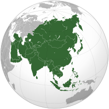
_political.svg) Afro-Eurasia shown in green
Afro-Eurasia shown in green
Geographical Asia is a cultural artifact of European conceptions of the world, beginning with the Ancient Greeks, being imposed onto other cultures, an imprecise concept causing endemic contention about what it means. Asia does not exactly correspond to the cultural borders of its various types of constituents.[35]
From the time of Herodotus a minority of geographers have rejected the three-continent system (Europe, Africa, Asia) on the grounds that there is no substantial physical separation between them.[36] For example, Sir Barry Cunliffe, the emeritus professor of European archeology at Oxford, argues that Europe has been geographically and culturally merely "the western excrescence of the continent of Asia".[37]
Geographically, Asia is the major eastern constituent of the continent of Eurasia with Europe being a northwestern peninsula of the landmass. Asia, Europe and Africa make up a single continuous landmass—Afro-Eurasia (except for the Suez Canal)—and share a common continental shelf. Almost all of Europe and a major part of Asia sit atop the Eurasian Plate, adjoined on the south by the Arabian and Indian Plate and with the easternmost part of Siberia (east of the Chersky Range) on the North American Plate.
Etymology
 Ptolemy's Asia
The term "Asia" is believed to originate in the Bronze Age placename Assuwa (Hittite: 𒀸𒋗𒉿, romanized: aš-šu-wa) which originally referred only to a portion of northwestern Anatolia. The term appears in Hittite records recounting how a confederation of Assuwan states including Troy unsuccessfully rebelled against the Hittite king Tudhaliya I around 1400 BCE.[38][39][40] Roughly contemporary Linear B documents contain the term asiwia (Mycenaean Greek: 𐀀𐀯𐀹𐀊, romanized: a-si-wi-ja), seemingly in reference to captives from the same area.[41][42].svg) The province of Asia highlighted (in red) within the Roman Empire
The province of Asia highlighted (in red) within the Roman Empire
Herodotus used the term Ἀσία in reference to Anatolia and the territory of the Persian Empire, in contrast to Greece and Egypt. He reports that Greeks assumed that Asia was named after the wife of Prometheus, but that Lydians say it was named after Asies, son of Cotys, who passed the name on to a tribe at Sardis.[43] In Greek mythology, "Asia" (Ἀσία) or "Asie" (Ἀσίη) was the name of a "Nymph or Titan goddess of Lydia".[44] The Iliad (attributed by the ancient Greeks to Homer) mentions two Phrygians in the Trojan War named Asios (an adjective meaning "Asian");[45] and also a marsh or lowland containing a marsh in Lydia as ασιος.[46] According to many Muslims, the term came from Ancient Egypt's Queen Asiya, the adoptive mother of Moses.[47]
The term was later adopted by the Romans, who used it in reference to the province of Asia, located in western Anatolia.[48] One of the first writers to use Asia as a name of the whole continent was Pliny.[49]
In languages of the Chinese character cultural sphere words related to the character 亜細亜 Yàxìyà are used. This has been criticized as implying an inferiority of the continent as 亜 means inferior. However it is a mere phonetic representation.
History
Main article: History of Asia The Silk Road connected civilizations across Asia.[50]
 The Mongol Empire at its greatest extent. The gray area is the later Timurid Empire.
The history of Asia can be seen as the distinct histories of several peripheral coastal regions: East Asia, South Asia, Southeast Asia, Central Asia, and West Asia. The coastal periphery was home to some of the world's earliest known civilizations, each of them developing around fertile river valleys. The civilizations in Mesopotamia, the Indus Valley and the Yellow River shared many similarities. These civilizations may well have exchanged technologies and ideas such as mathematics and the wheel. Other innovations, such as writing, seem to have been developed individually in each area. Cities, states and empires developed in these lowlands.
The central steppe region had long been inhabited by horse-mounted nomads who could reach all areas of Asia from the steppes. The earliest postulated expansion out of the steppe is that of the Indo-Europeans, who spread their languages into the Middle East, South Asia, and the borders of China, where the Tocharians resided. The northernmost part of Asia, including much of Siberia, was largely inaccessible to the steppe nomads, owing to the dense forests, climate and tundra. These areas remained very sparsely populated.
The center and the peripheries were mostly kept separated by mountains and deserts. The Caucasus and Himalaya mountains and the Karakum and Gobi deserts formed barriers that the steppe horsemen could cross only with difficulty. While the urban city dwellers were more advanced technologically and socially, in many cases they could do little in a military aspect to defend against the mounted hordes of the steppe. However, the lowlands did not have enough open grasslands to support a large horsebound force; for this and other reasons, the nomads who conquered states in China, India, and the Middle East often found themselves adapting to the local, more affluent societies.
The Islamic Caliphate's defeats of the Byzantine and Persian empires led to West Asia and southern parts of Central Asia and western parts of South Asia under its control during its conquests of the 7th century. The Mongol Empire conquered a large part of Asia in the 13th century, an area extending from China to Europe. Before the Mongol invasion, Song dynasty reportedly had approximately 120 million citizens; the 1300 census which followed the invasion reported roughly 60 million people.[51]
The Black Death, one of the most devastating pandemics in human history, is thought to have originated in the arid plains of central Asia, where it then travelled along the Silk Road.[52]
The Russian Empire began to expand into Asia from the 17th century, and would eventually take control of all of Siberia and most of Central Asia by the end of the 19th century. The Ottoman Empire controlled Anatolia, most of the Middle East, North Africa and the Balkans from the mid 16th century onwards. In the 17th century, the Manchu conquered China and established the Qing dynasty. The Islamic Mughal Empire and the Hindu Maratha Empire controlled much of India in the 16th and 18th centuries respectively.[53]
Western European colonisation of Asia coincided with the Industrial Revolution in the West and the dethroning of India and China as the world's foremost economies.[54] The British Empire became dominant in South Asia, with large parts of the region first being conquered by British traders before falling under direct British rule; extreme poverty doubled to over 50% during this era.[55] The Middle East was contested and partitioned by the British and French,[56] while Southeast Asia was carved up between the British, Dutch and French.[57] Various Western powers dominated China in what later became known as the "century of humiliation", with the British-supported opium trade and later Opium Wars resulting in China being forced into an unprecedented situation of importing more than it exported.[58][59] Foreign domination of China was furthered by the Empire of Japan, which controlled most of East Asia and much of Southeast Asia, New Guinea and the Pacific islands during this era; Japan's domination was enabled by its rapid rise that had taken place during the Meiji era of the late 19th century, in which it applied industrial knowledge learned from the West and thus overtook the rest of Asia.[60][61]
With the end of World War II in 1945 and the wartime ruination of Europe and imperial Japan, many countries in Asia were able to rapidly free themselves of colonial rule.[62] The independence of India came along with the carving out of a separate nation for the majority of Indian Muslims, which today has become the countries Pakistan and Bangladesh.[63]
Some Arab countries took economic advantage of massive oil deposits that were discovered in their territory, becoming globally influential.[64] East Asian nations (along with Singapore in Southeast Asia) became economically prosperous with high-growth "tiger economies",[65] with China regaining its place among the top two economies of the world by the 21st century.[66] India has grown significantly because of economic liberalisation that started in the 1990s,[67] with extreme poverty now below 20%.[68]

- The threefold division of the Old World into Europe, Asia and Africa has been in use since the 6th century BCE, due to Greek geographers such as Anaximander and Hecataeus.
-
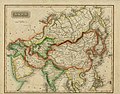
- 1825 map of Asia by Sidney Edwards Morse
-
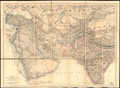
- Map of western, southern, and central Asia in 1885[69]
-
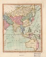
- The map of Asia in 1796, which also included the continent of Australia (then known as New Holland)
-

- 1890 map of Asia