The Carretera Granma: One of the most spectacular drives in
 Few travellers venture to Cuba's south-eastern corner, but a little-known road offers a fascinating – and stunning – glimpse of the nation's revolutionary past.
"We're going the back way to Santiago," I told the man at the car hire office in Bayamo, Cuba.
The manager looked at me and warned that this remote road lacks cell signal, and that if the car were to break down, it could be a long time before anyone arrived to rescue us.
Tracing the edge of eastern Cuba's foot-shaped Granma province, this back road, which Cubans call the Carretera Granma (or the southern coastal road), is so isolated that Fidel Castro, who launched his grass-roots revolution against the nation's US-backed president Fulgencio Batista here in 1956, only returned to the area once in his lifetime. The province is named after the 18m motor yacht Castro sailed from his exiled home in Mexico back to Cuba to overthrow the government.
After crash-landing almost 100m offshore and thrashing their way through more than 1km of thick mangroves near this very road, Castro, Che Guevara and 80 other revolutionaries set about making modern-day Cuba.
On paper, it makes sense for travellers wishing to go from Granma's capital, Bayamo, to Cuba's second city, Santiago de Cuba, to drive some 130km along the central highway.
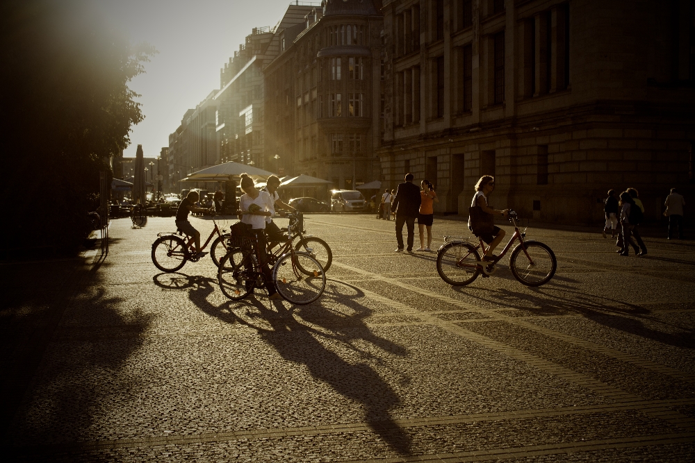
But this remote – and at times, rough – road that slaloms between the turquoise ocean and the steep slopes of the Sierra Maestra mountains on Cuba's southern edge is so magnificent in parts that it leaves drivers and passengers gawping in awe. In 25 years of travelling to the country, I've found it to be the most spectacular road trip in Cuba, and driving it reveals fascinating snapshots of the nation's revolutionary history alongside the jaw-dropping views.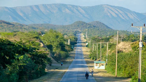
My trip would take me 420km in all, from Bayamo west to the coast, and then tracing Granma's triangular shape anticlockwise to Santiago de Cuba. I'd driven this road alone before, but because of Cuba's ongoing fuel shortages, I booked a second driver, Rafa González, through Bayamo Travel Agent. While a full tank would get us to Santiago, and Cuba is quite safe, I didn't fancy being stranded alone in case of breakdown on such a far-flung road with little to no mobile phone signal.
Driving in Cuba
Transtur is Cuba's state-run car hire service, though Novela Car is another popular car-hire aggregator and cars hired through them come with a full tank of petrol that doesn't need refilling when you return the vehicle. Fuel in Cuba is only bought with bank cards unconnected to US banks or with Clásica top-up cards bought from exchange bureaus (US$4/£3.15).
Hire cars must use "combustible especial" fuel which can only be bought at petrol stations in Bayamo, Manzanillo, Pilón and Santiago on this route.
Away from the Sierra Maestra, Granma is a province of rolling fields, tousled sugar cane, wide-open skies and cotton-ball clouds. It also proudly honours the region's rebellious past. As González and I bumped through the potholed roads out of Bayamo, we drove past key figures of Cuba's 1959 Revolution immortalised in painted portraits on large roadside stone slabs. I felt like I was travelling through the pages of a Cuban history book.
This road reveals traces of Cuban history long before the revolution, though. In the small town of Yara, 44km west of Bayamo, Hatuey, an aboriginal Taíno leader, was burnt at the stake by the Spaniards in 1512. Hatuey refused to convert to Christianity and was murdered for his heresy. His ashes spiralled skywards, inspiring the Luz de Yara legend that most Cubans grow up learning about a mysterious light sometimes seen dusting these faraway fields.
After stopping in the sleepy coastal town of Manzanillo for one of Cuba's best snacks, a small triangular pastelito de guayaba (guava pastry), we journeyed south-west along the ridge of Granma's "foot", where banana plantations, coconut palms and almond, flamboyán and mango trees crowded the grassy borders between the tarmac and lilting sugar cane.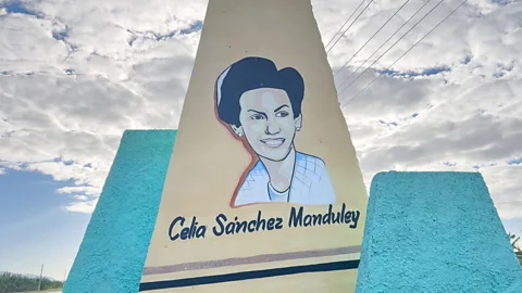
We pulled in at the ruins of La Demajagua sugar plantation, where in 1868, Carlos Manuel de Céspedes liberated his 53 slaves, marking Cuba's first wars of independence against Spain. Today, it's a peaceful site, with butterflies helicoptering over jasmine flowers, a small museum, a venerable jagüey tree shading the few ruins and a bell that once tolled for freedom.
Forty kilometres south in the town of Media Luna, we stopped at the birthplace-turned-museum of the Cuban revolutionary Celia Sánchez. A doctor's daughter, Sánchez spied for Castro's nascent 26th of July rebel movement and helped Castro and his men escape Batista's advancing troops after their Granma ship was wrecked offshore. She later became Castro's secretary, confidante and – some say – his lover.
After driving along the rough road for another 50km, we reached mainland Cuba's most southerly cul-de-sac, Cabo Cruz, home to a lone lighthouse, pelicans and a fishing community of 500 homes. Nearby is a series of eight Unesco-protected marine terraces, some climbing 360m high, resembling giant stepping stones. The area is also home to the 275 sq km forested Granma Landing National Park, which is dotted with karstic caves and is where Castro and his men washed up on shore in 1956.
The next morning, Leonel Fontaines Alvarez, a local guide, walked me 1,500m out to sea on a concrete platform to the spot where the revolutionaries landed. It's marked by a small stone and plaque – a modest monument for such a country-altering event.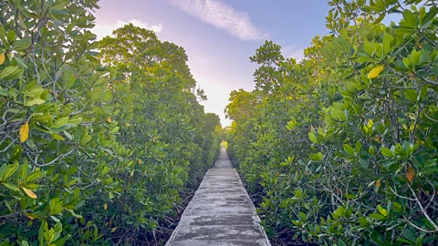 It took Castro and his men f
"You can see why Fidel and his men took five hours to clamber through the mangroves," he said, as we stared at the dense wall of green. "They carried 30kg backpacks, a 10kg Winchester rifle; they were not carrying a machete and didn't know where they were."
After scrambling through the mangroves, Castro and his men hid out in the nearby Sierra Maestra mountains for two years, surviving on meagre rations, battling disease and coming under fire from Batista's offensives. "In these Sierra Maestra years of their fight, most of the time Fidel's men faced the most precarious conditions anyone could ever experience," explained Yadi León Quintero, Alvarez's wife and also a guide.
They were hungry, thirsty, they had few weapons and they were strongly pursued by Batista's army.
From their mountain strongholds, the rebels attacked garrisons and coordinated their growing supporters. Castro biographer Robert E Quirk wrote that there was "no better place to hide" in the whole island than the Sierra Maestra, and their isolation in the impregnable mountain folds was key to the insurgency's success. Today, this coast that once echoed with gunshots is filled with the rustle and call of ibis and the endemic Cuban tody.
After a quick stop in coastal Niquero, close to where the revolutionaries had planned to come ashore before the Granma ran aground, we pushed south-east into the colossal Sierra Maestra mountain range that runs along the coast from Cabo Cruz past Santiago. The island's highest point, Pico Turquino (1,974m) rises from these rugged peaks, and Castro's secret rebel headquarters-turned-museum, La Comandancia de la Plata, is hidden in its deeply drawn folds. True to its remote location, you can't actually reach the museum from the road. Instead, it's a six-hour round-trip trek from Alto de Naranjo, 64km south of Bayamo, to reach this cluster of rustic wooden huts with basic beds, a field hospital and a radio station.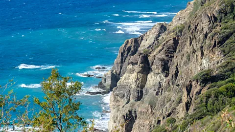 Driving east past the town of Pilón, stratified rock faces rose next to the tarmacked road, frayed on its edges and tumbling towards seagrape trees and the ocean. The road, more rutted now, climbed high with sweeping views of dark green peaks and riffling sea. After passing a couple of cowboys on horseback, Pico Turquino momentarily appeared in the distance before disappearing behind the clouds. The mountains reared up abruptly from the coast, their dramatic scarped slopes made it hard to keep our eyes on the road.
Pulling into the village of La Plata, we popped into the small Museo Combate de la Plata commemorating Castro's first revolutionary victory: an attack on a garrison in January 1957, confirming the "Rebel Army existed and was ready to fight", as Guevara said. The battle proved Castro was alive after Batista had declared him assassinated in an earlier skirmish.
Beyond La Plata, the road meandered around breath-taking coastline where indigo and turquoise water met grey-black sand coves. Just beyond the village of Uvero, where two monuments commemorate the first key battle of Castro's army in 1957 when the rebels ambushed an army garrison, the rumpled road flattened. We skirted villages tucked close to black and white sands en route to Santiago, which hosted Castro's victory speech on 1 January 1959 after Castro succeeded in ousting Batista from power.
Sixty-five years later, it's incredible to think that after it took Castro and his men two years on foot to reach the "Hero City", as Santiago is known, a scenic if seldom-travelled road allows travellers like me to retrace much of their epic journey.
The Open Road is a celebration of the world's most remarkable highways and byways, and a reminder that some of the greatest travel adventures happen via wheels.